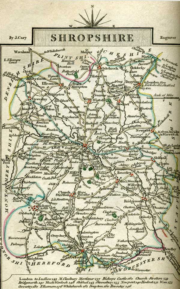
Shropshire
Carys New and Correct English Atlas: Being a New Set of County Maps from Actual Surveys. Exhibiting All the Direct & Principal Cross Roads, cities, Towns, and most considerable Villages, Parks, Rivers, Navigable Canals &c. Preceded by a General Map of South Britain, Shewing the Connexion of one Map with another. Also A General Description of each County, and Directions for the junction of Roads from one County to Another. London: Printed for John Cary, engraver & Map-seller, No. 181, near Norfolk Street, Strand, Published as the Act directs Jany. 1st, 1793:
Shropshire is an inland county, which, during the Saxon heptarchy, belonged to the kingdom of Mercia. It is now in the province of Canterbury, the dioceses of Hereford in part, and the remainder in that of Litchfield and Coventry, and is included in the Oxford circuit. It is 47 miles long, 38 broad, and 210 in circumference; containing 1320 square miles, divided into 15 hundreds, 170 parishes, and 15 market towns, viz. Shrewsbury, the county town, which fends 2 members to parliament, and gives the title of Earl to the Talbot family; as does Ludlow that of Viscount to the family of Herbert, and sends 2 members to parliament; as does Bridgenorth, Wenlock, and Bishop's Castle, 2 members each ; besides which, there are Drayton, Wem, and Oswestry, which latter gives the title of Baron to the Howard family; Whitchurch, Church Stretton, Cleobury, Newport, Shefnal, and Wellington; with Ellesmere, which gives the title of Baron to the Egerton family. The following villages give titles to noble families, viz. Clun, that of Baron to the family of Howard; Cherbury, the same title to that of Herbert; Harley, to that of Harley; and Powis, that of Earl and Baron to the family of Herbert. The principal rivers are the Tweed, Severn, Teem, Clun, Ony, Warren, Torn, Corve, Rea, Kemlot, and Mele. The most remarkable places are Wire, Morf and Hocifo Forests ; St. Gilbert's Caradock, Wrekin, Stipperston, Titterston Hill, Browncle, Brethen, Cleobury Mount, Burning Well, Bishop's Moot, Corvesdale, and Blaze Heath; Boscobel House and Grove, Caractacus's Camp, with Acton Burnell Castle and Barn. It sends 12 members to parliament, viz. 2 for the county, and 10 as before shewn; pays 7 parts of the land tax; and provides 640 men to the national militia. The air of this county is healthy, but cold. The soil in the vallies produces different sorts of grain, and upon the hills pasture for black cattle and sheep; besides which its chief produce is fruits, river fish, pit-coal, copper, lead, iron, stone, lime-stone, pitch, and tar. Its manufactures are gloves and stockings, woollen cloths, flannels, and cannon. It is reckoned the largest inland county in the kingdom.
|
|
| Quotations |
 Chapter 9 Chapter 9
Captain Wentworth was come to Kellynch as to a home, to stay as long as he liked, being as thoroughly the object of the Admiral's fraternal kindness as of his wife's. He had intended, on first arriving, to proceed very soon into Shropshire, and visit the brother settled in that county, but the attractions of Uppercross induced him to put this off. |
Chapter 14
Louisa was now recovering apace. Her mother could even think of her being able to join their party at home, before her brothers and sisters went to school again. The Harvilles had promised to come with her and stay at Uppercross whenever she returned. Captain Wentworth was gone for the present, to see his brother in Shropshire. |
Chapter 23
He had remained in Shropshire, lamenting the blindness of his own pride, and the blunders of his own calculations, till at once released from Louisa by the astonishing and felicitous intelligence of her engagement with Benwick. |
| |
|
|
|
|
|
|
|
© 2008 The Republic of Pemberley